Nice video ![]()

Nice video ![]()
Thanks for bringing all the work together (and having a nice ride at the same time)
Just to mention here:
I don’t think that this is an Strava topic. I can see the same effect using Tracks from komoot.
So I think the import to Garmin Connect seems to be the issue.
Hi and thanks for your reply.
Please have a look on my plot of the same 100km route. One from Garmin Connect, the other one from komoot directly.
For me it looks like the same topic, what do you think?
This will be food for thought at Garmin HQ!
Has anyone noticed that routes made in Strava have really precise elevation data where routes exported with RideWithGPS and created in Garmin directly smooth over the data.
I haven’t switched to the new roaming update for the 1040, just switched my source of data.
Feels like a whole new world when just using the map w/ elevation at the bottom.
That’s maybe the bug that @gpl was describing. I think I found it too on my recent trip to Spain. The routes from strava were pretty precise but the Garmin routes triggered climb pro off circa 0.2mi after the actual crest.
Exactly, the distance is correct, even the turn warnings are mostly accurate, but the climbs for some reason get farther and farther off as you progress on the route. The longer the route, the worse the are.
where are you seeing this?
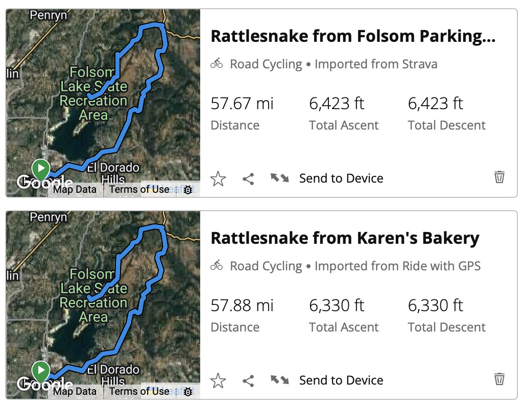
Two days ago I created a course in RideWithGPS:
57.9 miles and 6330 feet of climbing.
Pinned it in RWGPS and it synced to Garmin Connect:
and also auto-synced to my 840. On the Edge I was surprised to see bonus elevation:

Instead of 6330 ft of climbing, the 840 now had 8110 ft of climbing!
@KevinKlaes regarding your elevation comment I looked at a couple climbs…
for example climb #9 on RWPGS (pre-ride) has 677’ climbing:

but 732’ on the 840 ClimbPro:

Hard to exactly line up the climb between the 840, GC web, Strava, and TrainingPeaks, but I picked that one because it has a clear beginning/end and all uphill. Here goes:
| Climbing | Peak Elevation | |
|---|---|---|
| RWGPS route (pre-ride) | 677’ | 1366 feet above sea level |
| 840 ClimbPro (pre-ride) | 732’ | |
| Garmin Connect web (post-ride) | 689’ | 1364 feet above sea level |
| Strava (from Garmin ride file) | 664’ | 1367 feet above sea level |
| TrainingPeaks (from Garmin ride file) | 669’ | 1367 feet above sea level |
| VeloViewer - from Strava segment data | 664’ | 1211 feet above sea level |
Not sure where ClimbPro picked up 28% bonus climbing elevation on the entire ride (8110’ instead of 6330’).
The 14 climbs finished either at the top, or within 100’ of the summit either a little short or a little long. Really nothing to complain about during the ride, other than seeing estimated 8110’ on the climb review page at the beginning.
It kept decreasing the total climbing remaining during the ride, for example about 1/3 into the ride:

the Total Ascent + Ascent Remaining had dropped to just over 7400’ total climbing.
About 2/3 into the ride:

and total climbing had dropped to 7220.
Even later:
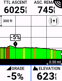
down to 6770 total climbing.
Small route change, probably a small 100’ bonus climbing, finished at 6529’ climbing.
ok this is interesting:
Here are the two routes in Garmin Connect (web or mobile):
The Strava file gets processed by ClimbPro and gives almost exact elevation as yesterday’s recorded ride:

![]()
More complex routes are easier to make in RWGPS, but pre-ride I prefer to review the route in Strava. Now I have a reason to do just that LOL.
Also, FWIW, on the Activity Profile I tried changing from All Climbs to Major Climbs and that had no impact on the RWGPS route showing wrong total climbing (it always showed 8110’).
Last week I began using an Edge 540. This weekends ride was the first one where I used Climb Pro - and I noticed a lag also. I created the route on the Garmin Connect app for iOS.
Is there any resolution to the lag issue with climb pro?
In dcrainmaker’s review I recall him stating that Garmin is slightly behind the Wahoo/Hammerhead units in responding to climbs initially, but once on the climbs themselves the Garmin units are more accurate to overall gradient changes than the competition
I’m not seeing the phase shifting of elevation when using Strava loaded/starred routes. What I am seeing is that Garmin provides a much more flat profile. On Strava I’ll see the ups and downs of a route with color changes to yellow on the elevation screen and minimap w/ elevation. This is very noticeable with rollers. I’ll try to find an example this week. It’s like Strava writes in more points with elevation data and the other programs just smooths over it.
I’ve added this to a couple of other threads also. This is what I get when I import the 2023 Unbound course into my Edge 840.
The elevation data is way wrong. So seems like the Garmin Edge devices have issues not only with Climb Pro, but with elevation data in general.
Here’s what I get for this years Unbound course:
The biggest difference happens when the route is synched with the Edge device.
Any ideas?
Ride with GPS
Ride with GPS imported to Garmin Connect
Route imported from Unbound website to Connect
Ride with GPS route on Edge 840
Native Garmin Connect route on Edge 840